Search This Blog

Showing posts with label Casuarina Camping Area. Show all posts

Tuesday, June 28, 2016

Shared Walks in Glen Rock State Forest, QLD.

Before arriving at Glen Rock State Forest we printed out a shared trail map. It turned out to be a good thing that we brought our own map because we couldn't find any information about walks at the campground or in the information hut. Even with the map we had a great deal of trouble finding the starting point for Christies Loop. We walked back along the entry road and eventually noticed a new shinny gate in a fence. We could just make out another new gate on the other side of the paddock which was flanked by a couple of green posts of a type commonly used in national parks. Throughout the walk we came upon several green posts whenever there was a choice in direction to be made but unfortunately they were all new and none of them had any arrows or other information on them. As we climbed we had phone reception so we ended up using Google Earth to guide us. We had to backtrack a couple of times but there wasn't much chance of getting completely lost as there were fantastic views of the valley below. We were more concerned about adding too many extra kilometers to the walk as the going was pretty tough. Later, a ranger told us that 4WD clubs had helped the rangers by installing the green posts. As we packed up to leave the campground, members from a couple of 4WD clubs were arriving for the weekend to continue helping with the establishment of the trails. 

Christies Loop, 5.2 km return. Shared walking, horse and mountain bike trail. Good fitness is required because the trail has a very steep ascent and a very steep descent. 

The starting point of Christies Loop. Only a few cow pats to negotiate!
The walk crosses the valley floor and climbs to the top of the ridge before descending again. The only answer to "Why did we do it?" is "Because it was there!".

The creek crossing was completely dry.
At the top of the ridge looking back at Glen Rock.
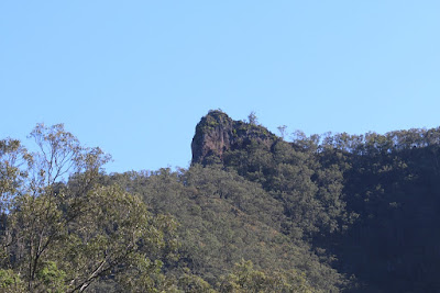
Our destination.
From here we walked on the most pleasant part of the trail to another peak only to discover, when we looked at Google Earth, that this wasn't part of Christies Loop and we had to back track.

The pleasant part of the trail that wasn't part of the trail after all.
Rufous Whistler, female.
We didn't see a great variety of birds on this walk but there were quite a few Yellow-faced Honeyeaters, Rufous Whistlers and Fairy Wrens.

The descent required a bit of concentration as it is quite steep but before long we were back walking along the creek bed. We saw a few cows on the walk but they seemed quite shy. In our absence a herd of cows had moved into the paddock, even though we tried not to disturb them, they quickly left when we showed up.


Blackfellow Creek Trail, 16 km return. Shared walking, horse and mountain bike trail. 

Blackfellow Creek Trail
This trail heads along the valley floor towards Main Range National Park. The walk is easy and pleasant. We didn't see any other people but we could see wildlife footprints along the track. The trail went past Glen Rock and we were able to view it from a different angle.
Dingo and Eastern Grey Kangaroo footprints.
Glen Rock
We noticed that large numbers of Double-barred Finch were sheltering in lantana alongside the track. Thankfully some of them emerged enough for us to get photos.
Spot the Double-barred Finch.

There were also plenty of Silvereyes feeding alongside the track.

Silvereye.
Soon we came to a waterhole and after that the creek was flowing and we saw a greater variety of birds.

The first waterhole that hadn't completely dried out.
White-necked Heron
White-faced Heron.
Rosellas
Rufous Whistler, male.
We arrived at a creek crossing and startled a magnificent adult Brown Goshawk. We spent the next 20 minutes playing hide and seek with the goshawk in the hope of getting a usable photo but goshawks are very intelligent and it had no intention of giving us a good view. 

Coming up to the creek crossing where we startled a brown Goshawk.
We found several pupal cases emerging from the ground but we didn't see any Rain Moths. We did see lots of Monarch butterflies.
Monarch Butterfly Danaus plexippus and Pupal Case of the Rain Moth Trictena atripalpis
We had spent so much time taking photos that we ran out of time to complete the walk and we reluctantly decided to return to the campground. We will definitely be back.

Wednesday, June 15, 2016

Casuarina Camping Area, Glen Rock State Forest, QLD.

Glen Rock, reflecting the setting sun.
The drive south from Gatton to Glen Rock has great views of the food producing farms along the valley floor. We passed an organic pecan farm and a paddock with three camels. Closer to the campground there are Brahman cattle farms where the cattle come in three colours; red, black or white.


Food crops growing in fertile alluvial soil.
Pecan trees.
Red, white and black Brahmans.
The road has been done up since it was extensively damaged by flooding and is in good condition. The concrete causeways, some with 3m markers, indicate that flooding should be taken seriously around here.


We set up in the well appointed campground and had the place to ourselves for a couple of days before people started arriving from the Mitsubishi 4WD Club for a working-bee to help the rangers. 

Casuarina Camping Area, Glen Rock State Forest.
There is a slab hut opposite the campground which is used as an information centre. We browsed through the hut but had to return with a torch to read the maps as it is surprising dark inside.


Slab Hut at Glen Rock State Forest.
Detail: slab hut at Glen Rock.
A resident goanna cruised around the campground. 


Lace Monitor (goanna)  Varanus varius
The most common birds in the campground were Noisy Miners but Grey-crowned Babblers were also present as well as Butcherbirds and Magpies. Every afternoon Rosella's flew overhead. There were Crimson Rosella's and Eastern Rosella's and large numbers of birds that at first glance appeared to be Pale-headed Rosella's but proved to be hybrids on closer inspection. Despite their numbers they proved challenging to get photos of.


Grey-crowned Babbler
We noticed strange alien-like creatures had emerged from holes in the ground. Upon further research I discovered that this is the empty pupal case of a Bardi Grub. The grub is actually the caterpillar of the large Rain Moth and it lives in the ground for many years feeding on the roots of trees. The adult emerges just before heavy rain, typically from April to June, leaving the empty case sticking out of the ground. 

8 cm pupal case of the Rain Moth Trictena atripalpis

Details for Casuarina Camping Area, Glen Rock State Forest, QLD.

Access: Narrow sealed roads in good condition for most of the way. Good dirt road for the last few kilometers. Caution: this is a floodplain.

Directions: Glen Rock State Forest is 42 km south of Gatton, on East Haldon Road via Tenthill and Junction View. The route is well sign posted.
Type of Camping: tent beside your car, caravans, camper trailer, motor home. Maximum stay of 30 days.

Sites: Not numbered. One large grassy area with two sites and another large grassy area divided into 4 large sites with small trees separating each site. Each site suitable for up to 12 people. Also a group camping area and a horse yard (a new yard was being constructed while we were there).
Facilities: drop toilets, cold showers, covered tables in each site, fire rings, non-potable water taps. BYO wood. Walking is permitted on roads and tracks. Shared walking, horse and mountain bike trails. No bins. We had no Telstra phone reception. 

Prohibitions: No domestic pets except horses. No generators. Do not collect firewood from the park.

Fees: $5.95 per person, children under 5 years are free. There is a Family Rate of $23.80 for 1 to 2 adults with children under the age of 18, with a maximum of 8 people in total. 

Bookings: Phone 13 74 68 or online at https://qpws.usedirect.com/QPWS/Facilities/SearchView.aspx

Cautions: Floodplain: some causeways have 3m flood indicators. Narrow bridges, causeways and grids. The creek near the campground was completely dry while we were there. One of the campsites was heavily affected by ants.

Day Use Area: Large shelter with tables and wood BBQ's, individual tables and wood BBQ's, drop toilets. Bush Tucker Walk.

Wildlife List for this trip:
Eastern Grey Kangaroo. Wild dogs/Dingoes could be heard at night and we saw their footprints when we went on the Blackfellow Creek Walk. The ranger we spoke to said there are Dingoes in the area. Unidentified small and large bats.
Butterflies: Large numbers of Monarch and Lesser Wanderer. 
Birds: Pacific Black Duck, White-necked Heron, White-faced Heron, Masked Lapwing, Wedge-tailed Eagle, Brown Goshawk, Peaceful Dove, Bar-shouldered Dove, Crested Pigeon, Galah, Australian King Parrot, Crimson Rosella, Eastern Rosella, Eastern Rosella hybrids, Laughing Kookaburra, Rainbow Bee-eater, White-throated Treecreeper, Variegated Fairy-wren, Striped Honeyeater, Noisy Miner, Yellow-throated Miner, Lewin’s Honeyeater, Yellow-faced Honeyeater, Striped Honeyeater, Eastern Whipbird, Grey-crowned Babbler, Jacky Winter, Grey Shrike-thrush, Rufous Whistler, Grey Fantail, Willie Wagtail, Magpie-lark, Dusky Woodswallow, Grey Butcherbird, Pied Butcherbird, Australian Magpie, Pied Currawong, Australian Raven, Welcome Swallow, Golden-headed Cisticola, Double-barred Finch, Silvereye.