Search This Blog

Friday, December 8, 2017

Wreck Rock Campground and Middle Rock Campground, Deepwater National Park, QLD.

Wreck Rock.

Wreck Rock Camping Area

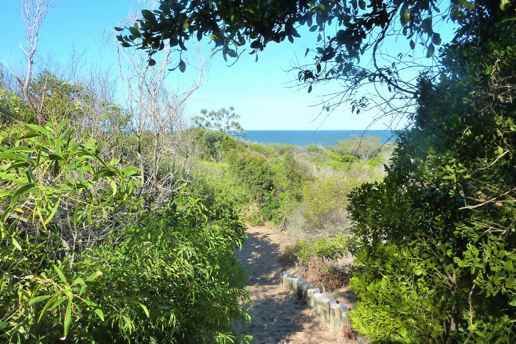
We really enjoyed camping at Wreck Rock. The sites are protected from the wind and nicely separated. It is only a short walk to Wreck Rock Beach.

Wreck Rock Camping Area.
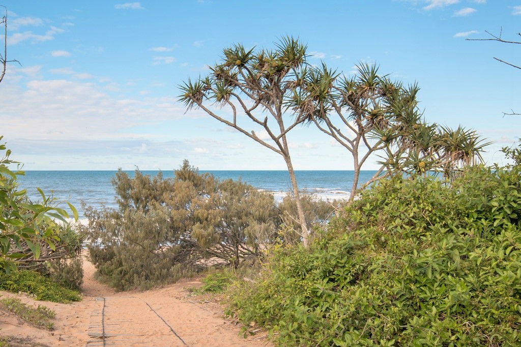
Access to Wreck Rock Beach.
Wreck Rock Beach

Details for Wreck Rock Campground:
Where: 114 km, 1 hour 36 minutes, north of Bundaberg.
Access: 2WD access from the south or high clearance 4WD access from Agnes Water in the north. The campground itself requires some clearance in one short section (i.e. I wouldn't take my Mazda 3) There was water over the causeway and some water over the road when we went there in November 2017.
Fees & Booking: Standard National Parks QLD fees. $6.35 per adult per night. Must book before arrival https://qpws.usedirect.com/qpws/ or by phone 13 74 68 no phone reception at the campground.
Sites: Suitable for vehicle based camping, tents and campertrailers. Listed as "not suitable for caravans" on the website (no room to maneuver) 14 defined, hard sand sites. Most sites have a table and fire place. Behind fore dunes with no view of the beach.
Facilities: Male and female composting toilets. Outdoor cold shower. Also one tap with non-potable bore water in the campground. Tables. Fire places (BYO wood). Short walk to the beach and Wreck Rock.
Prohibited: Pets, collecting wood, chainsaws, beach driving.
Fun Fact: Ocean turtles nest along the beach from October to April. Turtles emerge from the nests from January.

Middle Rock Camping Area

There was no one camping at Middle Rock when we were there, however, a few 4WD enthusiasts passed by from time to time. Although we like remote and quiet camping areas we did prefer Wreck Rock as there is no water and no toilets at Middle Rock and it is a longer walk to the beach.


Entry to Middle Rock Camping Area
A site at Middle Rock Camping Area
The beach is a fair distance from the campground.
The beach in front of the camping area at Middle Rock.

Details for Middle Rock Camping Area:
Where: 14 km south of Agnes Water. 3 km north of Wreck Rock Camping Area.
Access: High clearance 4WD.
Fees & Booking: Standard National Parks QLD fees. $6.35 per adult per night. Must book before arrival https://qpws.usedirect.com/qpws/ or by phone 13 74 68 no phone reception at the campground.
Sites: High clearance camper trailers and 4WD vehicle based tent camping behind fore dunes in sites defined on the information map.
Facilities: Fire rings and tables. There are no toilets and no water. Longer walk to the beach than Wreck Rock Camping Area.
Prohibited: Pets, chainsaws, driving on beach.


Wednesday, November 22, 2017

Harding's Paddock, QLD.

Harding's Paddock Picnic Area
Harding's Paddock Picnic Area and Harding's Paddock Campground form part of the Flinders - Goolman Conservation Estate and are managed by the City of Ipswich. The picnic area is a huge grassy area containing a lagoon and several sheltered picnic tables with electric BBQ's.

One of several picnic shelters.
The campground is gated and you will receive a code for the gate when you make your booking. There are eight sites, each with a parking area big enough for a caravan or motorhome and a picnic table with a grassy area at the back for tents. This design may not be suitable for some camper trailers. Fires aren't permitted at the camp sites but there is a large communal fire ring between the campground and the camp kitchen. There is also an adjoining horse holding yard so although this is usually a quiet campground it can become very busy if a group activity is booked in.

Example of an individual site: parking area in the front and a table and tent area at the back.
There is a central grassy area behind the sites for tents.
In a separate area, there is a large camp kitchen, toilets, fire ring and shower cubicles (BYO shower bag).

Camp Kitchen with toilet block in the background.
Several walks of varying difficulty leave from the picnic area. Flinder's Plum Picnic Area is about 18 km away (by car) and also has some walking trails in the conservation estate.

Details for Harding's Paddock Campground:
Where: About 55 km south-west of Brisbane or 40 km north of Boonah. The picnic and camping areas are at the end of Carmichaels Road (not Ellison Road as stated by Google Maps).
Access: Carmichaels Road is a 2WD unsealed road with some pot holes.
Sites: 8 individual numbered sites. Suitable for tents, caravans and motorhomes. 
Bookings and Fees: https://www.discoveripswich.com.au/accommodation/hardings-paddock-campground/ or phone 07 3281 0555   $12 per site per night.
Facilities: Gated campground. Tables in each campsite. Communal Camp Kitchen (with water, sink, tables and BBQ's), fire ring (BYO wood), toilets, shower cubicles (BYO Bag). Horse Yard with water. Walks.
Prohibited: Pets. Fires at camp sites. Collecting wood.
Caution: The Ipswich area can become very hot and there isn't much shade in the campground.

Saturday, November 11, 2017

Koreelah National Park, NSW.

Koreelah Creek Campground
We drove to Koreelah National Park via Mount Lindsay Road and turned north into White Swamp Road. 
The sealed and unsealed sections of White Swamp Road.
Despite encountering a fair bit of rain and some thunder storms, including some pea sized hail, we really enjoyed camping at Koreelah Creek Camping Area. It is a very well maintained park and we saw the ranger every day. Although this campground can get busy on weekends and holidays it was very peaceful while we were there. Most of the camp sites are perched above the creek, however, most don't have a view of the water. Nevertheless, we loved listening to the murmuring of the water as it flowed by.


Our campsite got a little wet but our trusty tent survived the hail.
The Gorge Walking Track (800 m return, Grade 2) starts in the campground, meanders alongside the creek, past a day use area and finishes at a small waterfall that flows into Koreelah Gorge.

Koreelah Falls
Koreelah Gorge
There were a lot of large Bandicoot holes throughout the campground so we were hopeful that we would be able to identify which Bandicoot was responsible but to our surprise we didn't manage to see any at all. The rain seemed to have stirred up the frogs though and there appeared to be thousands croaking in the night. At least they proved a little easier to find than the Bandicoots.
Stony Creek Frogs Litoria wilcoxii
These fungi were thriving in the wet conditions.
We went for a night walk and didn't see any animals until, as often seems to be the way, we returned to our campsite and there was a Common Brushtail Possum checking out our site while we were away.

Common Brushtail Possum
Of course it fined up the morning we were leaving. We were glad the sun came out though because we saw a group of Cunningham's Skinks sunning themselves on some rocks. They are very large skinks, a bit smaller than Land Mullets, so you would think they would be easy to photograph but they quickly retreat into rock crevices if they notice you and it can be quite a challenge to catch them unawares. With a fair bit of stealth and patience we were finally able to get some photos of them.


Cunningham's Skink
We saw quite a few butterflies about and a good variety of birds in the campground. 
Female Orchard Swallowtail Papilio aegeus, and Brown Ringlet Hypocysta metirius.
Crimson Rosalla
Scarlet Honeyeater and Dusky Woodswallow.

Details for Koreelah Creek Campground:
Where: In NSW just over the QLD/NSW border. About 2 hours south-west of Brisbane. 37 km north-west of Woodenbong. 
Access: 12 km north of Koreelah including a 3 km section of dirt road.
Sites: Grass and dirt sites suitable for: tent camping beside your vehicle, camper trailers and caravans. Unpowered.
Facilities: Drop toilets, fire places (BYO wood), tables. No taps or drinking water.
Prohibited: Pets, generators, smoking.
Fees and Bookings: Self-register at information sign. No bookings. No vehicle entry fee. Camping $6 per adult, $3.50 per child. 
Caution: Ticks. Near the falls it is slippery and there is a sudden drop off.

Wildlife List: Cunningham's Skink, Lace Monitor, Red-necked Wallaby, lots of bandicoot holes. Stony Creek Frogs.
Bird List: Whistling Kite, Satin Bowerbird, Grey Butcherbird, Sulphur-crested Cockatoo, Little Cormorant, White-bellied Cuckoo-shrike, Pied Currawong, Torresian Crow, Australian Wood Duck, Spangled Drongo, Superb Fairy-wren, Variegated Fairy-wren, Red-backed Fairy-wren, Grey Fantail, Rufous Fantail, Red-browed Finch, Leaden Flycatcher, White-faced Heron, Yellow-faced Honeyeater, White-naped Honeyeater, Scarlet Honeyeater, Jacky Winter, Sacred Kingfisher, Laughing Kookaburra, Australian Magpie, Noisy Miner, Black-faced Monarch, Australian King Parrot, Eastern Rosella, Crimson Rosella, Little Shrike-thrush, Grey Shrike-thrush, Welcome Swallow, Brown Thornbill, White-throated Treecreeper, Eastern Whipbird, Rufous Whistler, Willie Wagtail, Dusky Woodswallow. Heard Pheasant Coucal.

Monday, November 6, 2017

Queen Mary Falls Caravan Park, QLD.

Queen Mary Falls Caravan Park and Cafe
The Queen Mary Falls Caravan Park is conveniently located opposite the Queen Mary Falls section of Main Range National Park. There is an excellent Day Use Area in the national park but no camping is allowed.

There is a cafe at the front of the caravan park which also serves as the office for checking in. We received a friendly greeting and were made to feel welcome. There are powered and unpowered sections available as well as a few cabins. We chose to camp in the unpowered section and we had the area to ourselves. 
A couple of the cabins at Queen Mary Falls Caravan Park
Camping in the unpowered section.
Feeding native birds with seed purchased at the cafe is a popular activity. As a result, there are lots of birds in the campground. As soon as we pulled up to our site Australian King Parrots came to visit us. 


The King Parrots arrived before we had a chance to get out of the car.
As we have a low impact philosophy regarding nature we don't feed wildlife but it was pleasant to sit in the campground observing various birds grazing in the grass. Crimson Rosellas and Eastern Rosellas were a colourful sight.
Eastern Rosella, Galahs, Crimson Rosella and a Wonga Pigeon.
There is a camp kitchen with a large barbecue and a wood stove for keeping warm on cold nights. It was surprisingly cool at night when we were there in late October. The amenities block is old but importantly there was plenty of hot water for a shower. If you like bush style caravan parks then you will be happy here but if you like resort style caravan parks then this caravan park may not appeal to you. We were perfectly happy to have a place to camp next to a national park with flushing toilets and hot showers.

The camp kitchen.
While we were there, we were lucky to witness the farmer next door muster a large herd of cattle. It was great to see the dogs and horses working together.

Mustering on Spring Creek Road.

Details for Queen Mary Falls Caravan Park:
Where: 150 km south-west of Brisbane.11 km east of Killarney. 
Address: 676 Spring Creek Road, Killarney, QLD, 4373.
Contact: 07 4664 7151   www.queenmaryfallscaravanpark.com.au
Fees: We paid $25 per night, unpowered.
Facilities: Amenities block with flush toilets and hot showers. Bins. Fire rings (BYO or purchase wood from cafe). Camp Kitchen with sink, tables, oven, microwave, BBQ,wood stove, kettle, toaster but no cutlery, plates or cooking equipment. Laundry.
Sites: The powered area has tiered (flat) sites for caravans, trailers and motor homes. The unpowered area is an open grass area with some shade trees.
Cafe: There is a popular cafe at the entrance which also serves as the caravan park office. Gas refills. Ice.
Of Note: Bird feeding in front of the cafe. Dogs are allowed, please check first. Conveniently located opposite the Queen Mary Falls Day Use Area and walks.


Saturday, November 4, 2017

Spring Creek Road Scenic Drive, Boonah to Killarney, QLD.

Queen Mary Falls
After weeks of very dry weather it was finally raining and we thought it would be a great time to see a few waterfalls. On this road trip we chose to drive to Queen Mary Falls via the scenic route from Boonah along Carney's Creek Road and Spring Creek Road. This route is not suitable for caravans or heavy vehicles.


The small town of Boonah was looking great as the Jacaranda trees were in full bloom. There is an excellent Information Centre in Bicentennial Park on the Boonah-Fassifern Road. Free overnight camping is permitted in the car park for self-contained motor homes and caravans. 


If you are self-contained you can stay the night in the Boonah Information Centre Car Park.
Our first stop on the scenic route was Teviot Falls. These are intermittent falls best viewed after heavy rain. However, it's worth stopping anytime for the view.


Teviot Falls
View from Teviot Falls Lookout.
Our second stop was Carr's Lookout where there is a constructed walkway and lookout with an expansive view out over the surrounding countryside. Spring Creek Cafe and Cottages is also located here.


Carr's Lookout
View from Carr's Lookout
We continued on to Queen Mary Falls. There is a Day Use Area in the national park and the Queen Mary Falls Caravan Park and Cafe is across the road. Bird feeding is a popular activity in front of the Cafe. 


Queen Mary Falls Day Use Area
Queen Mary Falls Cafe and Caravan Park Office.
It is only a short walk to the lookout overlooking Queen Mary Falls.


Queen Mary Falls from the Lookout.
Continuing the scenic drive towards Killarney; Daggs Falls is the next stop. Here there is a constructed lookout and a sheltered picnic table but no toilets. Dogs are allowed.


Dagg's Falls Lookout.
Dagg's Falls
Browns Falls Park is only a further 1.2 km along Spring Creek Road. Here there are toilets, picnic tables and a children's playground. It is only a short walk of 600 m to Brown's Falls from here, however, the track is unformed and it is necessary to cross the creek three times so this walk is not for everybody. No sooner had we set out under the tunnels than it started to thunder and rain so we made the decision to retreat back to the car.

This is an excellent day trip. Choose between returning the way you came, cutting across to Cunningham's Gap or doing a circuit through Koreela, White Swamp Road and Carney's Creek Road. We choose to head into northern New South Wales.

Monday, October 30, 2017

Queen Mary Falls Section of Main Range National Park, QLD.

 Queen Mary Falls.
The Queen Mary Falls section of Main Range National Park is on Spring Creek Road between Boonah and Killarney. Camping is not allowed in this section of Main Range National Park but there is a privately run Caravan Park and Cafe across the road from the Queen Mary Falls Day Use Area. The Day Use Area is quite large with several separate areas, however, the car park can be full on Sundays.


Queen Mary Falls Day Use Area.
We saw a Satin Bowerbird guarding his bower between the road and the Day Use Area. 


We haven't seen fresh grass growing in a bower before.
Due to the bird-feeding activities across the road at the Caravan Park Cafe there are usually lots of Australian King Parrots and Crimson Rosellas about.

The walks leave from the Day Use Area.
Cliff Circuit, Class 2, 400 m return:
This is an easy short walk but doesn't have great views of the falls. However, about half of the circuit is also part of the Queen Mary Falls Circuit and I feel, that if you prefer short walks or are in a hurry, you would find it more rewarding to walk to the Lookout on the Queen Mary Falls Circuit and return the same way.

Queen Mary Falls Circuit, Class 3, 2 km return:
Although this walk descends to the base of the falls before climbing again to the Day Use Area we found the walk easier than we expected. The track meanders alongside Spring Creek before the creek plunges over the falls. There is an easy crossing over Spring Creek by a foot bridge and it is only a short distance to the lookout which has excellent views of the falls.


Crossing Spring Creek to get to the lookout is easy.
The lookout on the Queen Mary Falls Circuit.
Queen Mary Falls viewed from the Lookout.
We continued on and descended to the base of the falls. There was a rainbow at the base of the falls and excellent views back up to the lookout.

There were lots of Eastern Water Dragons on the rocks at the base of the falls.

Eastern Water Dragon
The circuit continues on, zig zagging to the Day Use Area via a few steps.
The descent and ascent to the Day Use Area was surprisingly good for bird watching considering how many people pass through every day. 

Spotted Pardalote
Black-faced Monarch

Details for Queen Mary Falls Section of Main Range National Park, QLD:
Access: South-west of Brisbane. Choice 1: The scenic route is 64 km south-west of Boona via Carneys Creek Road and Spring Creek Road. This route is very steep and unsuitable for caravans or trucks over 3 tonnes. Choice 2: the Day Use Area can be reached via Warwick and Killarney. Choice 3: Take Freestone Road off the Cunningham Highway and drive via Yangan and Emu Vale.
Caution: Sheer cliffs. Supervise children closely.

Queen Mary Falls Day Use Area:
Where: Opposite the Queen Mary Falls Caravan Park and Cafe on Spring Creek Road.
Facilities: Drop toilets, tables, picnic shelter, wood BBQ's (BYO wood) and free electric BBQ's, walks, information sign. No bins.
Prohibited: Pets. Camping. Collecting wood from the park.
Note: Gets very busy on Sundays. At the time of our visit in October 2017 the toilets were in the most disgusting condition of any toilet we have ever seen!

Bird List: Satin Bowerbird, Grey Butcherbird, Pied Butcherbird, Sulphur-crested Cockatoo, Galah, Fan-tailed Cuckoo, Pied Currawong, Australian Wood Duck, Superb Fairy-wren, Grey Fantail, Red-browed Finch, Leaden Flycatcher, Fairy Gerygone, Blue-faced Honeyeater, Lewin's Honeyeater, Laughing Kookaburra, Rainbow Lorikeet, Australian Magpie, Noisy Miner, Black-faced Monarch, Spotted Pardalote, Australian King Parrot, Pheasant Coucal, Wonga Pigeon, Eastern Yellow Robin, Eastern Rosella, Crimson Rosella, White-browed Scrubwren, Eastern Spinebill, Welcome Swallow, Brown Thornbill, Red-browed Treecreeper, White-throated Treecreeper, Eastern Whipbird. Heard: Bell Miners along Spring Creek Road.