Search This Blog

Monday, December 8, 2014

Tomaree National Park, NSW.

In April last year we headed 50 km north-east of Newcastle and discovered Shoal Bay and Tomaree National Park.  You can not camp in Tomaree National Park but there are several caravan parks and rental accommodation available in the area. We had a leisurely stroll along the foreshore at Shoal Bay and stopped for lunch before walking to the summit of Mount Tomaree.

Shoal Bay with Mount Tomaree, right.

Lace Monitor beside the path.

Red Wattlebird

Tomaree Head Summit Walk

This walk involves climbing up several levels of metal steps so it requires some fitness. There seems to be a tradition of placing "love" padlocks on the walkways.

Straight up to the summit of Mount Tomaree

"Love" padlocks

The views at the top are simply stunning. The weather was perfect and the sky was so blue, the ocean so clear and the small volcanic mountains so green that we were thoroughly blown away by the beauty of Tomaree National Park and the whole surrounding area.


Looking back at Shoal Bay

Looking down at Zenith Beach and Stephens Peak

The view of Point Stephens Light House on Fingal Island

On the way down we took an easy paved path to the World War II gun emplacements. The gun emplacements were part of Fort Tomaree and were built in 1941 to defend the east coast of Australia. There are fantastic views of Yacaaba Headland from here.

Fort Tomaree Gun Emplacement

Yacaaba Headland

We were so inspired by the views from the summit and the gun emplacements that we promised ourselves that we would return and walk in all the beautiful areas that were laid out below Tomaree Head. 

Friday, December 5, 2014

Parklakes Wetland, Bli Bli, Sunshine Coast, QLD

Parklakes is a little unusual as a destination for us as it is an artificial lake and wetlands area created by the Parklands housing estate developers. It is a pleasant walk around the waterways on a concrete path with views of abundant birdlife.

Parklakes, Bli Bli 

Parklakes  is on the Yandina-Bli Bli Road. We turned into the large car park and walked across the sports field to do a circuit walk around the lake and wetlands. There were several Pipits on the sports field when we visited in July but we didn’t see any on our latest visit in November.

Australian (Richard's) Pipit

Natives have been planted around the outside of the lake which attract birds. Some of the birds we have seen include Willie Wagtails, Magpie-Larks, Butcherbirds, Red-backed Fairy Wrens, Double-barred Finches, Golden Whistlers, Rufous Whistlers and Brown Honeyeaters.


Banksia

Double-barred Finch

Golden Whistler

Brown Honeyeater

Rufous Whistler

There were lots of dragonflies about on our recent visit.


Common Glider Tramea loweii

Slender Skimmer Orthetrum sabina

This Eastern Water Skink was out in the sun near the water.


Eastern Water Skink Eulamprus quoyii,

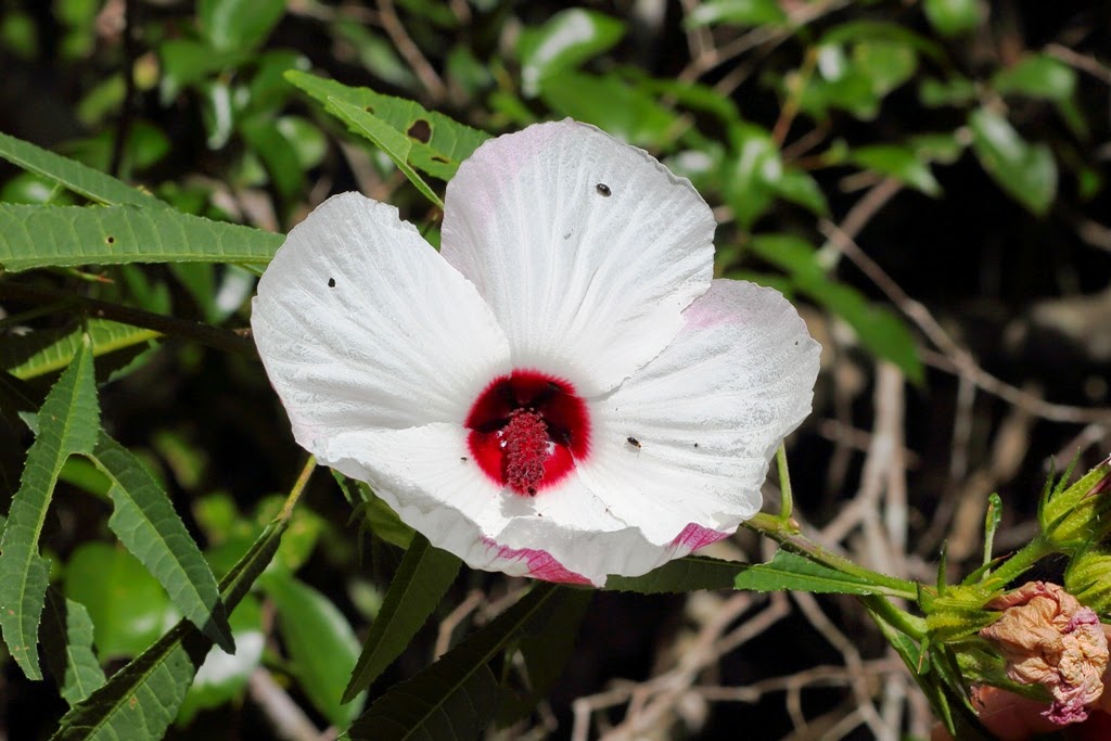
The white form of Native Hibiscus was in flower. We love the candy stripe side view of this insect attracting flower.

Native Hibiscus Hibiscus heterophyllus

Native hibiscus Hibiscus heterophyllus

Water Lilies at Parklakes

Wetland birds are the stars at Parklakes. Below is a selection of birds that we photographed at Parklakes.


Comb-crested Jacana

Baillon's Crake

Purple Swamphen with Hatchling

Magpie Geese

Pied Cormorant

Intermediate Egret

Little Black Cormorant

White-faced Heron

Royal Spoonbill

Eurasian Coot
Hardhead
Pacific Black Duck
 Hybrid duck

There have been some sightings of interesting birds around the lakes by better birders than us. Greg Roberts from sunshinecoastbirds  http://sunshinecoastbirds.blogspot.com.au/ has posted photos of Australian Little Bittern and Spotless Crake seen at Parklakes. 

Update Feburary 2016: Unfortunately, there have been very dissapointing developments at Parklakes as reported by Greg Roberts here. After a couple of visits to Parklakes we saw a Spotted Crake there which was a "lifer" for us and we are saddened by this latest news.

Monday, December 1, 2014

Sanctuary Mountain Maungarautari, North Island, New Zealand

Maungatautari Mountain

In January we were lucky to go to Sanctuary Mountain Maungatautari or Maungatautari Ecological Island as it is also called, in New Zealand. The sanctuary encloses 34 square kilometers of a forested volcanic mountain with 47 km of pest-proof fencing. As pests are eradicated on the inside and keep outside by the fence the forest and native fauna have returned both naturally and through reintroduction.


The forest enclosed in the Xcluder pest-proof fence.

Sanctuary Mountain Maungatautari is less than a three hour drive south of Auckland. Please get directions from the Sanctuary website because Goggle Maps gives directions to a completely different side of the mountain.

http://www.sanctuarymountain.co.nz/how_to_get_here

The Manu Tioriori Visitor Centre is open 7 days a week from 10am to 4pm in the winter and 10am to 6pm in the summer. We paid a fee of $17 per adult ($10 senior/Student) and $7 per child to enter the Southern Enclosure. There are guided tours available or you can take one of the walks at your own pace. We were short of time and choose to walk around the Southern Enclosure Track.


The Southern Enclosure Track

Epiphytes in the forest.

Mamaku (Black Ponga)

We saw several insect nesting boxes attached to trees along the track. Studies have shown that the native beetle population has increased enormously since the enclosure was erected. Native beetles increased 300% from 2004 to 2007 alone.

Insect Nesting Boxes

As we approached the Canopy Tower we were really excited to see several Kākā Nestor meridionalis flying around. I got a bit over excited and took a number of blurry photos as they flew backwards and forwards quite close to us.

  • Kākā, (Nestor meridionalis)
  • Kākā, (Nestor meridionalis)
We climbed the Canopy Tower and enjoyed the views out over the forest.

Looking down from the Canopy Tower

View from the Canopy Tower

    Wood Pigeon (Kererū) (Hemiphaga novaeseelandiae)
On our way out we visited the Kakapo enclosure. It's fairly rare to get the opportunity to see Sirocco the Kakapo but we were able to watch a video of his antics. Hopefully, one day, Kakapos will live safely in large numbers at Maungatautari.


Sigh! This is only a photo of a photo of Sirocco at the enclosure.

We only touched the surface at Sanctuary Mountain Maungatautari. There are more walks and a wetland area to see as well. We could easily have spent three or four days just walking around and observing this magnificent project.

Thursday, November 27, 2014

Lake Tarawera Outlet and Tarawera Falls, North Island, New Zealand

In January we went to Lake Tarawera Outlet in New Zealand. This beautiful area has a large DOC (Department of Conservation) campground and is the starting point for the Tarawera Outlet to (Tarawera) Falls Track.
Lake Tarawera Outlet, looking west over LakeTarawera

Lake Tarawera Outlet, looking north. 
The Lake Tarawera Outlet Campsite has 50 tent sites, tap water, toilets, a cooking shelter, picnic tables and a boat ramp. Dogs are permitted on leash. It is $6 per adult and $3 for 5 to 17 year olds, per night. No bookings are taken. There is also a permit required to access the forestry road to the campsite which costs $5. Tickets are purchased at Kawerau Information Centre, Plunket Street, Kawerau. Kawerau is about 55 km east of Rotorua and the drive is very scenic. 


Lake Rotoma, between Rotorua and Kawerau.

Be sure to get directions and a map to Lake Tarawera Outlet Campsite from the Kawerau Information Centre because Goggle Maps lists the campground as only 1.6 km away which is not the case. The campground is on the eastern shore of Lake Tarawera, approximately 25 km from Kawerau by good gravel roads. The forestry gate is closed at night and during times of high fire danger.


Kawerau, looking at Mount Edgecumbe.
Forestry Road to Lake Tarawera Outlet (looking back towards Mt Edgecumbe).
A footbridge links the campground to the Tarawera Outlet to (Tarawera) Falls Track. The track is 3.5 km one way with an estimated time of 2 hours. Turn right after the bridge. This section of Tarawera River is a designated Trout Spawning Sanctuary.


Looking west from the bridge over Tarawera River to Lake Tarawera.

Footbridge over Tarawera River, looking back at the Campground and Mount Tarawera.

Looking east from the bridge over Tarawera River.

The walking track mostly follows the river which is unbelievably clear and beautiful. 

Tarawera River
A short section of the track is over a dry volcanic plain.


Dry volcanic section of the track.

Then the track returns to follow Tarawera River.


Tarawera River

The Cascades, Tarawera River.
We didn't have a birding camera with us but we did manage to get a photo of a gorgeous Tomtit; a bird we don't have in Australia.


Tomtit
We turned around where the track descends steeply down to the waterfall and returned to the campground. Later in the day we drove to the Tarawera Falls carpark and walked the short distance to the base of the falls where there is a viewing area and seats. 


The walk to Tarawera Falls from the carpark.

Tarawera Falls is the most stunning waterfall we have ever seen. This photo simply does not do it justice. The water gushes out of the rock face in several places and the noise is incredible.


Tarawera Falls

In all out travels, the Tarawera area would have to rate as one of the most beautiful places we have ever seen.